Nambour’s October rain passes 480mm, more than four times the monthly average
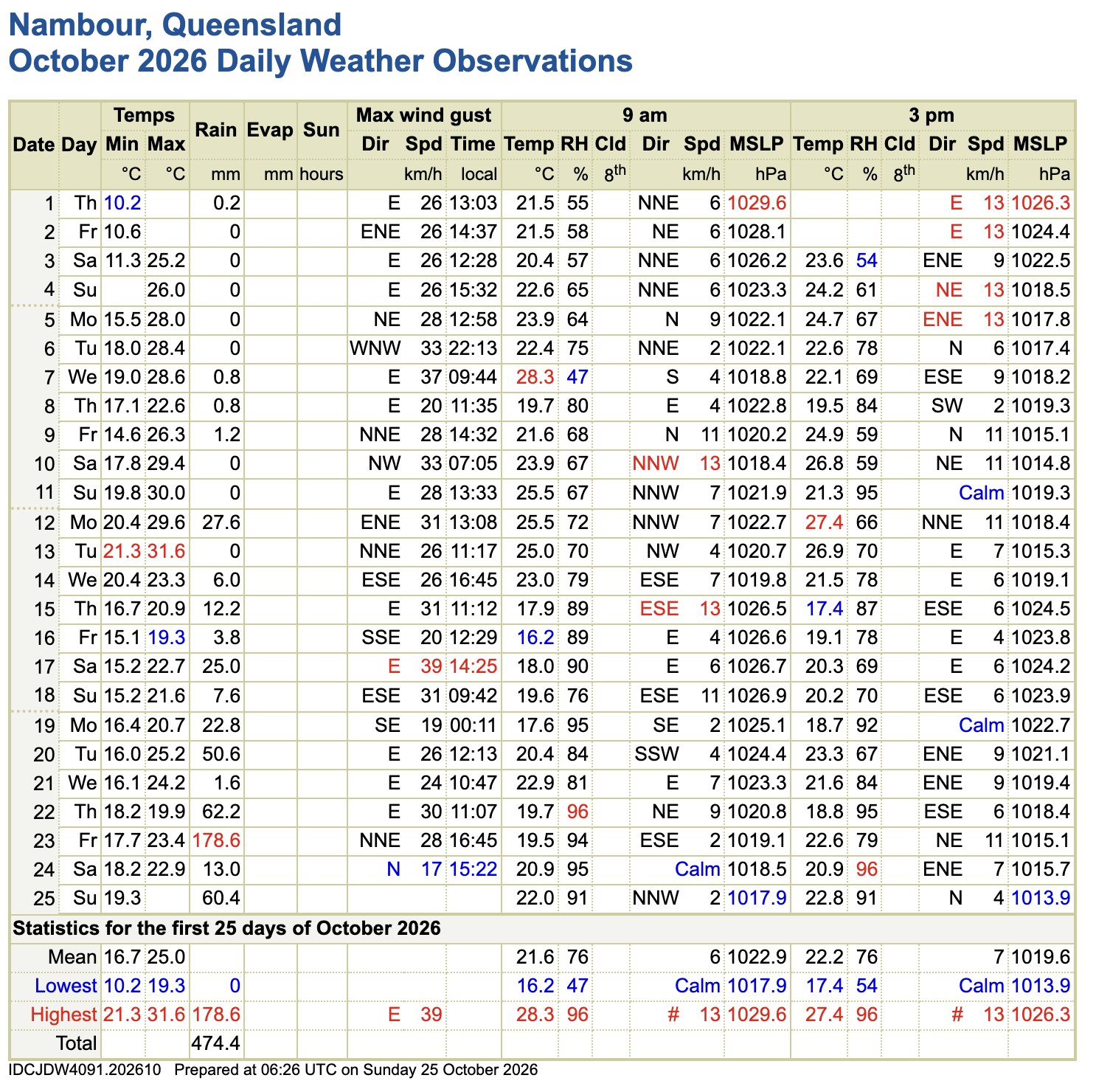
Nambour has recorded 482.4mm of rain this October, more than four times the month’s long-term average of 104mm, with a possibly severe thunderstorm forecast for the Sunshine Coast today (Monday Oct 26).
Bureau of Meteorology observations from the Nambour Hillside station show the total for the 26 days to 9am Monday. It is more than a quarter of the town’s average annual rainfall of 1712mm, and nearly double the average for February, usually the wettest month.
The month began almost dry, with just 3mm in the first 11 days. The rain started on 12 October with 27.6mm and has fallen every day since the 14th.
The 105mm recorded in the eight days to 19 October has since been dwarfed, with another 397mm falling in the eight days to Monday.
The heaviest fall was 178.6mm in the 24 hours to 9am on Friday 23 October. It followed 62.2mm the day before, and a further 60.4mm fell in the 24 hours to 9am Sunday. In the five days to Monday morning, Nambour received 322mm.
The Bureau’s Nambour forecast for Monday is for showers and a developing storm, with 1 to 25mm possible and a 90 per cent chance of rain. A thunderstorm is likely in the afternoon and evening, possibly severe, with damaging winds, large hail and heavy rain that may lead to flash flooding. The top temperature is 30C.
Bureau senior meteorologist Angus Hines said the storm risk will push north on Tuesday and Wednesday, targeting areas from the Sunshine Coast to Townsville. Nambour is forecast to receive up to 7mm on Tuesday and up to 10mm on Wednesday, with a chance of thunderstorms both days.
Conditions are expected to improve from Thursday, with 0 to 1mm forecast for Thursday and Friday and only light falls over the weekend.
Residents are urged to monitor emergency warnings and never drive through floodwaters.
Further afield more than 160mm fell in three hours at Caboolture on Thursday. Further north, Brooweena in the Wide Bay-Burnett region received 211mm in 24 hours to 9am Sunday, breaking a 27-year October record there. A major flood warning was issued for the Mary River at Tiaro, and Gympie experienced minor flooding.
Overnight storms on Monday dropped more than 100mm in six hours in parts of the Gold Coast Hinterland and southwest Brisbane, with Tarome recording 111mm between midnight and 6am.
The wet spell has been driven by a blocking high in the Tasman Sea, which is now moving away from the coast.